A few photos from Devon.
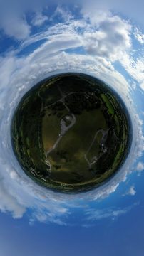
RAF Harrowbeer
RAF Harrowbeer – if you look closely you can see the old runway.

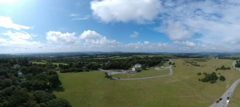
View over Horrabridge
A few photos from Devon.
RAF Harrowbeer
RAF Harrowbeer – if you look closely you can see the old runway.
View over Horrabridge
Umm lovely….
Taking a break in the West Country, and just dropped by Dartmoor, where I knew there would be an ice cream van!
I also cam here to fly my drone, outside the National Park!

Lovely my Lover!
A quick flight to the allotments and back…
This short 5 minute 1080P HD clip was recorded at 8.30am on the 19 December, it’s not snow on the roads, it’s just a hard frost. It’s at approximately 30 feet above the ground.
Watch as I miss a telephone line by inches, and also look out for Angus!
It gives me an idea of the road conditions before driving to work…as the first two miles of driving in rural Yorkshire can be very hazardous as the roads are NOT gritted!
I’ve had a cold for a week, so not been feeling well enough to concentrate whilst flying…
So today, built up enough confidence to fly at 400 feet, which is The Drone code Be Drone Safe proposed rules for safe flying of drones maximum “safe” altitude.
What I didn’t expect was the the iPhone application to crash, leaving my drone at 400 feet! It sounds worse than it did, because I was able to restart the application, re-connect to the drone, and issue a return to home.
I could have brought it home using the remote controller, which connects to the drone, the Phone and App connect to the remote controller, and in the event, it loses contact with the remote control will issue a return to home!
So panic over!
I managed to solve the issue with the App, by removing the video cache, and later this afternoon, re-visited 400 feet to take this photograph.

Click to enlarge!
I’ve wanted one for five years, after flying a larger drone.

DJI Spark Fly Combo

DJI Spark "Sparky" Meadow Green edition

DJI Spark "Sparky" Meadow Green edition
and this is a picture of my allotments

Gravel Pit Field Allotments from 350 feet
![[Valid RSS]](http://andysworld.org.uk/images/valid-rss.png "Validate my RSS feed")